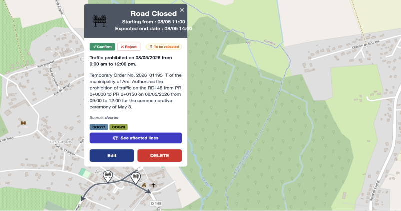
ALERT

Nextérité’s solutions identify and qualify mobility information across all modes: road, public transport, bicycle, shared mobility, parking, from several dozen different sources: sensors, traffic data, official information, traveler messages, cameras, etc.

Information is disseminated through multiple channels: operator and local authority applications, information panels, SMS, email… and is integrated into route calculators.

The service is easily adaptable according to regions, networks and languages used. It is accessible via APIs.

ADDED VALUE

Up to 100% additional information

compared to official sources

An average 20-minute advance

compared to official sources

A well-informed person during disruptions experiences three times less delay, as they can choose alternatives and better plan their journey, regardless of mode*.

This improvement has a beneficial effect in the form of a virtuous circle:

well-informed motorists reduce their travel time and associated pollution

satisfied travelers turn more readily to public transport, which in turn becomes more profitable

  • “Impacts of real-time information levels in public transport” – Paulsen, Rasmussen, Nielsen (base de plus de 800k trajets) 

Benefits for residents

  • Reduced uncertainty and stress
  • Optimized travel
  • Sense of control and transparency
  • Enhanced accessibility for people with disabilities

Advantages for operators and authorities

  • Better regulation of mobility flows
  • Increased public transport ridership
  • Reduced pollution through modal shift
  • Optimized operations during disruptions
  • Reduced operational costs (staff, complaints)

MAIN FEATURES

  • Real-time data on mobility conditions across all modes (public transport, shared mobility, cars, and heavy goods vehicles), by line, route, and road network, within a given territory
  • SMS or email alerts by road network, public transport line, or route
  • Integration into route calculations (see pricing)
  • Use of real-world data for predictive modeling (see pricing)


Additional modules

  • GTFS, NeTEx, DATEX, Waze, and SAE connectors
  • Alerts for operators and residents
  • Detection of traffic conditions through image analysis
  • Semantic analysis of official decrees (roadworks, events)

Compelling testimonials

Use cases

How La Réunion manages real-time traffic information and increases resident satisfaction with ViaPro and ViaFacil

Tramway construction works: predictive and real-time information for residents of Le Havre Seine Métropole

How Deutsche Bahn improved real-time traffic information, and increased passenger satisfaction

Our other services

Mobility supervision. Crisis management. 

Parking availability, shared transportation, routes, etc …

Origin / Destination. Understand daily journeys. Visualization and analysis

Vous souhaitez en savoir plus sur nos solutions, échanger sur des partenariats potentiels ou vos besoins et problématiques en termes de mobilité ? 

Renseignez le formulaire ci-dessous avec l’ensemble de vos coordonnées, nous vous contacterons dans les meilleurs délais.

Recevez notre newsletter pour suivre notre actualité et nos événements

The exchange of data makes it possible to better respond to the mobility challenges of cities and territories around the world.

Do you have data that has an impact on mobility: works, traffic jams, weather, events, etc…?

Fill in the form below, we will contact you shortly.